Aerial photography is a technique that captures imagery from way up in the air. This method of photography aims to capture high-resolution photos of large areas and open spaces.
Professional aerial imagery is used not just for awe-inspiring posters, digital wallpapers, or postcards for tourists. Nowadays, aerial imaging technology is being used by a wide variety of businesses and organizations, especially since the advent of modern commercial drones with impressive high-definition photo/video capture capabilities.
Additionally, aerial photography in GIS (geographical information services) can benefit businesses across different industries, from real estate to roofing, construction, agriculture, or any organization that requires comprehensive images of geographical or land-based assets that they can combine with other datasets to maximize their geographical and geospatial intelligence initiatives.
So, how do businesses and organizations utilize aerial photography? Below are some of the ways that organizations leverage aerial imagery to benefit their business.
Practical Uses for Aerial Photography in Business Operations
1) Aerial photos of prime properties for real estate
Professional photography has always been a major component of real estate marketing. Realtors and real estate firms aim to sell property at the best price possible, so it only makes sense to get as much imagery of the property being sold as possible to provide to potential buyers, so they can make an informed decision on whether to go for the purchase.
Now, even though beautiful and well-decorated interior photos of a house that’s going up for sale can go a long way toward closing the deal, aerial photography has become a crucial part of the marketing strategy of modern real estate companies and professionals. Aerial imagery, be it photos or videos, provides potential buyers with a more complete perspective about the property that they’re looking to purchase.
Commercial drone technology, coupled with advanced camera technology that’s capable of delivering high-resolution imagery, has become the norm for most businesses and organizations in the real estate sector. For investors looking to buy land or families trying to purchase a house, aerial imaging offers a more comprehensive look at the property, including the surrounding area.
Although most of the more established commercial real estate firms have already been utilizing aerial photography for quite some time now, the rapid advancement of drone technology has made it more affordable, easier to operate, and more accessible to all kinds of users and real estate companies, regardless of their size or experience.
2) Aerial photography for the travel and tourism industry
The travel and tourism industry is a highly competitive one, accentuating the importance of first impressions. With professional aerial imagery, travel agents and organizations can provide high-quality photos and travel videos to potential clients. Aerial photos can provide visitors with a unique and exciting perspective when viewing their destinations.
Aerial photography can also be used to provide tourists with a glimpse of remote locations that they could choose to visit. Moreover, drone technology can also be utilized to capture exciting live-action shots. For example, resorts and adventure travel destinations can use aerial imaging to capture climbers scaling a steep mountainside, off-road bikers negotiating a challenging trail, or a group of tourists having the best time of their lives experiencing whitewater rafting for the first time.
When it comes to marketing tourist destinations, aerial photography can play a key role in showcasing the different outdoor amenities, features, and activities that potential guests can enjoy.
One of the first things that potential visitors and guests do when visiting any resort or tourism website is the photo/video gallery. This is because they want to see what the resort has to offer and determine exactly what they will be paying for should they choose to travel there. This is why many hotels, resorts, and travel destinations today are relying not just on professional photography for interior and eye-level shots of the property but on aerial images as well.
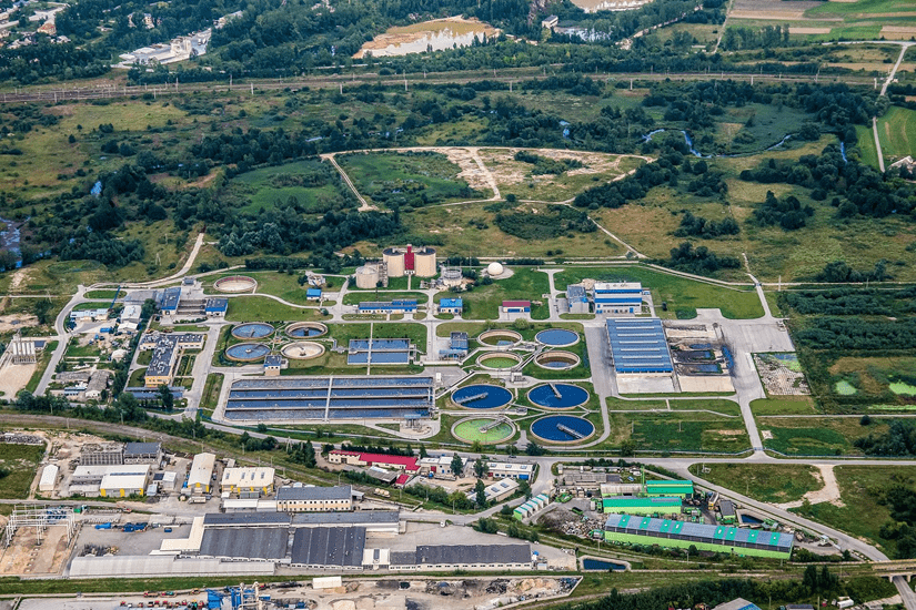
3) Urban development evaluation and implementation
The process of evaluating and implementing urban development projects can be quite a challenge for anyone, even for those with ample resources and years of experience. Aerial photography, in this sector, is another tool that decision-makers, government agencies, and community leaders will gladly add to their existing toolkit.
With urban development, professionals combine multiple technologies to produce a practical and cost-effective geographical information system (GIS). They bring together drone technology, high-resolution image/video capture technology, as well as modern mapping technology to deliver high-definition aerial imaging, with the ability to display geospatial data and large-scale geographical changes over extended periods.
In addition, many government agencies and organizations started using aerial imagery and modern mapping technology to evaluate, monitor, and implement their urbanization initiatives. However, all that urbanization necessitates is the further development of existing infrastructure as well as the addition of new ones, which will require geospatial intelligence that professional aerial photography and other geographical and geospatial mapping tools can provide.
With aerial imaging and location intelligence solutions, developers and decision-makers can identify the changes quicker and then come up with better improvements to their existing infrastructure. Aerial photography in GIS solutions is often used along with 3D tools to provide users with the ability to fully visualize any captured landscape from various vantage points. This method can give developers all the data they need to figure out when to build or upgrade an infrastructure and in which location. Imagery analysis will then provide a visual representation of year-over-year changes and progress.
4) Aerial photography in roofing and construction
This is another business sector where aerial photography, along with other GIS and mapping solutions, can be extremely useful, benefiting roofing contractors and construction companies, as well as their clients.
The advent of affordable, high-quality commercial drones with cameras that can capture high-resolution images and video has made it possible for businesses, particularly roofing contractors and construction companies to offer roof/site inspections using aerial imaging. Using drones to conduct roof inspections is safer and more cost-effective compared to the old method of having to send people onto the roof to physically evaluate its condition.
The use of aerial photography can also help roofing contractors and construction firms when making estimates for a project, as it enables them to perform a more detailed examination of the roof or site. In the case of roofs, they can extensively study the peaks, valleys, and ridges, and then make more precise measurements to avoid wastage.
A popular tool that many roofing professionals use for aerial roof measurements is Geospan’s gPro – 99% Accurate Roof Measurements. It uses patented roofing technology, without the use of drones, that can measure the total roof area, identify the material, the pitch, and facet total of a roof. The service comes with complete 3D aerial images of the roof of the property and utilizes AI technology to provide accurate measurements of every edge type of the single or multi family, residential or commercial structure . This is best suited for roofers and contractors looking to get accurate measurements , so they can quickly do more estimates more precisely, optimize labor and materials, and help prevent materials and labor errors – making it an invaluable and cost-effective tool for estimating, winning and completing more projects.
5) Monitor changes in vegetation and wildlife for large properties
Non-profit organizations that manage protected parks, landowners, and companies invested in fairly large properties can benefit from using aerial photography to closely monitor the changes in vegetation and foliage within their property. Foliage and vegetation can vary depending on the environment and location of the property, so using aerial imagery coupled with geospatial/location intelligence can facilitate the tracking and evaluation process of different landscapes.
The camera technology that is being used by today’s professionals can provide basic high-definition images, with a top-down perspective, providing landowners with a comprehensive view of their property or non-profits with their protected parks and wildlife sanctuaries. In addition to aerial photos, aerial photography in GIS solutions can provide additional insights to anyone who needs them, especially those systems that leverage AI technology for geospatial intelligence. These systems can deliver greater clarity in terms of insights related to vegetation levels, characteristics, and changes over time. Insights from aerial imaging and AI-driven geospatial intelligence can be leveraged to make data-driven decisions about areas for reforestation or other environmental projects. Mango farmers with multiple acres of trees or cattle ranchers with free-range cattle on wide open spaces of land can use aerial imagery along with geospatial intelligence to facilitate their decision-making process.
The Role of Geospan in the Aerial Photography Space
Geospan is the company behind a growing portfolio of technologically advanced products designed for organizations across different industries, including construction and insurance. Their products, such as gSquare and gPro, use technology based on patented GIS intellectual property to deliver solutions for government and industry users.
The company has been in operation for over 30 years and thanks to the great advancement of technologies like data management, high-speed computing, and AI, Geospan has currently been experiencing remarkable success with its products. Geospan is also the only company that has won a lawsuit against EagleView in 2013 for patent infringement. The suit claimed that EagleView was using patented technology that Geospan invented in 1997. The court ruled in favor of Geospan, and to date is the only company that has successfully battled EagleView and won.
Hey welcome to my blog . I am a modern women who love to share any tips on lifestyle, health, travel. Hope you join me in this journey!

Speak Your Mind